How can geographic information systems be improved to contribute to a more accurate understanding of the world?
How can geographic information systems be improved to contribute to a more accurate understanding of the world?
A scientific paper identifies five challenges yet to be solved using current geographic information systems (GIS), focusing on how to represent complex meanings of place, incorporate emotions, include new scales, address time and change, and integrate relational spatial approaches. Its authors are Núria Font Casaseca and Maria Rodó-Zárate, researchers with the Research Group on Gender and Inequalities (GRETA) of the UPF Department of Political and Social Sciences, within the framework of the European research project INTERMAPS.

GIS, geographic information systems, are technological tools that allow organizing, relating, locating, analysing and representing spatial data. Based on spatial location and 3D scenes, they organize layers of information and reveal a deeper knowledge of data, to identify patterns, relationships and characteristics of places, which help users make decisions.
However, the concept of absolute space on which conventional GIS are based often conditions the way in which data are categorized, analysed and represented, and marginalizes other perspectives, scales and dimensions. This restricted vision can lead to ignoring alternative possibilities and promoting a biased understanding of the world.
Precisely to explore the territory located in the margins of this tradition, and to describe its limitations, address challenges and offer new proposals, the two researchers of the Research Group on Gender and Inequalities (GRETA) of the UPF Department of Political and Social Sciences, Núria Font-Casaseca i Maria Rodó-Zárate, have published an article in Progress in Human Geography, one of the most influential international journals in the field of geography.
“Our proposals deal with specific concerns that do not fit in existing GISystems and suggest a creative engagement with mapping technologies to further expand our understanding of what GIS could be”
Going beyond traditional GIS margins
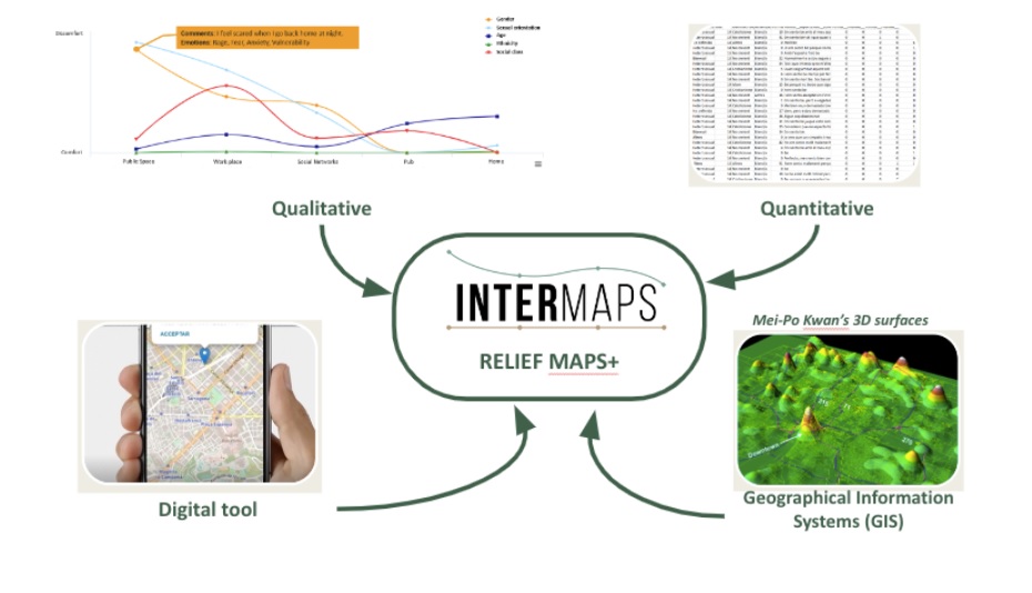
This work, one of the first outcomes of the INTERMAPS project, funded by the European Union with a European Research Council Starting Grant, of which Maria Rodó-Zárate is the principal investigator, makes a significant contribution to the field of geographic information systems (GIS): it explores the potential of a proactive commitment to cartographic technologies from peripheral positions, both from multiple perspectives, such as humanist, feminist, decolonial, queer and black, and from different disciplines, with the inclusion of digital and spatial humanities. In relation to INTERMAPS, this contribution lays the theoretical and epistemological foundations for the development of the Relief Maps+ tool, one of the core results of the project that aims to develop new digital and visual tools to collect spatial data on inequalities and discrimination.
This exercise is carried out to overcome what the authors identify as five intrinsic challenges of GIS: representing place; collecting and representing emotions; including scales such as the home or the body; addressing time and change, and integrating relational approaches.
Maria Rodó-Zárate and Núria Font-Casaseca wish to go beyond the institutional geospatial culture, as a way of rethinking the understanding of what GIS could be and expand the limits of its use for research: “Our proposals deal with specific concerns that do not fit in existing GISystems and suggest a creative engagement with mapping technologies to further expand our understanding of what GIS could be”, they point out.
The five major challenges of geographic information systems
1- How to represent complex meanings of place and how to overcome the intrinsic limitations imposed by a system of Cartesian coordinates that excludes spatial information that cannot be placed at an exact latitude and longitude.
2- How to collect and represent emotions: GIS and maps have been presented as neutral, scientific and objective technologies. However, mapping lived experiences requires reconsidering the subjectivity and positionality of cartographic tools.
3- How to include scales such as home or body: despite their central role in social sciences, intimate scales such as the body, home, or other private spaces are difficult to map and are therefore often absent from GIS analysis.
4- How to address time and change: despite the dynamic nature of many pressing issues, geospatial technologies may encounter difficulties to represent temporality and experiences that are often overlooked in official narratives.
5- How to integrate relational spatial approaches: distant sites are often represented as being disconnected from each other in GIS. Efforts to represent connections between scales, time and places are relevant to the social sciences.
For each of the five challenges, the authors provide examples of innovative and alternative approaches and initiatives, by various authors, that challenge, rework and reinvent other ways of relating to geospatial technologies.
Some of the many proposals that explain, respectively, each of the five challenges, are the following: the visualization “I Was There, Places of Experience in the Holocaust”, a map that offers visual representations of the various locations with interviews with Holocaust survivors, that highlight significant places linked to their memories; the “HarassMap”, a collaborative map that tracks incidents of sexual harassment and violence in Egypt.
Other examples are body and “body-territory” mapping, methods that place the body as a unit of analysis of spatial dynamics, emotions, violence and inequalities; the “Million Dollars Block” project, which addresses the spatial inequality of imprisonment and the return to the US, or the “Relief Maps+”, a tool developed by Maria Rodó-Zárate to collect, analyse and visualize data on intersecting inequalities and their spatializations from an emotional perspective.
“With our recommendations, professionals and scholars of GIS can broaden their horizons, beyond conventional software, through participating with these alternative ways of understanding and analysing spatial data, and avoid reproducing structures of domination and invisibilities in the production of geographical knowledge”, the authors conclude.
Reference work: Font-Casaseca, N., Rodó-Zárate, M (April 2024). “From the margins of Geographical Information Systems: Limitations, challenges, and proposals”, Progress in Human Geography
https://doi.org/10.1177/03091325241240231