
MISSED
Investigating Micro-scale Socio Ecological Dynamics in Marginal Zones: an Integrated Methodology
My research explores local aspects of human/environmental dynamics in the Murghab delta, an inland alluvial fan in southeastern Turkmenistan. This river delta, which loses its waters in the sands of the hyper-arid Karakum desert, has borne witness to human occupation since at least the late 3rd millennium BC and possibly earlier.
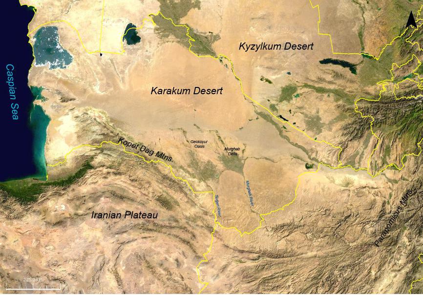
Much of the research in this area has focused on regional dynamics of this alluvial fan and on understanding the broad social and cultural trajectories of the societies that inhabited the region; a series of projects begun in the mid 1990s has sought to develop an understanding of the social, hydrological and geomorphological trajectories from the Bronze Age through the Islamic period. While this research has revealed a great deal about the relationships between human occupation and the natural environment, we still know very little about the local factors that shaped these dynamics. These local aspects are especially critical in marginal environments such as the Murghab, because the fragility and instability of such regions can dramatically amplify local changes both in the natural environment as well as in anthropogenic activities such as irrigation, land clearance or overgrazing, thus affecting the natural balance between people and landscape.
Thus, the regional "story" of these societies and their natural environments may ultimately be told at the local level-the level at which humans actually experienced and shaped their natural environments-and were in turn shaped by these environments.
My research is designed to emphasize locality in this marginal alluvial region, and to understand its importance in the broader picture of human/environmental dynamics-not only in this particular alluvial fan, but in marginal alluvial environments more generally. To this end, the research has three aims:
- To develop an approach to study human/environmental relationships at the micro-scale level via the integration of remote-sensing and geoarchaeology
- To better understand the co-evolution of micro-environments and human occupation within the wider context of marginal environments.
- To contribute to the development of a socio-ecological model that can help to understand alluvial fans/oasis environments in arid zones
Methods
To identify these local-scale dynamics, this project will make use of an integrated methodology that incorporates remote sensing data from satellite imagery and UAV (drone) acquired photography and geoarchaeological sampling of test pits from archaeologically rich areas in the northern part of the delta. This provides an opportunity to acquire data at multiple analytical scales-ranging from the regional level (e.g. low-medium resolution ASTER and LANDSAT satellite imagery) through the subregional and local scale (e.g. high-resolution Quickbird imagery and Terrasar X Spotlight imagery, and ultra-high resolution UAV-acquired data, to the hyper-local (e.g. the punctuated datasets from individual sampling areas).
Geoarchaeological sampling includes bulk samples (every 5cm) to evaluate sedimentological changes over time. These will be subject to numerous analyses including Loss on Ignition to determine organic content, geochemical analysis to evaluate trace elements, magnetic susceptibility and particle size analysis. Further analysis will include OSL dating and micromorphology, to gain an understanding of the depositional processes and chronology of the underlying alluvial sediments and the encroachment of sand dunes. This data will be evaluated in the context of archaeological data from survey and light excavation to understand the diachronic exploitation of the landscape.
Study Area
The study area itself is in a remote region referred to as Egri Bogaz, in which a series of small sites dating to the Bronze Age (roughly late 3rd to early 2nd millennium BC) were found in the 1980s and 1990s. The region represents a transitional environment between delta and desert, marked by dune hillocks and ridges loosely oriented from north to south, shaped by the prevailing northly winds. The interdune environments often contain takyrs-flat, polygonally cracked clayey surfaces with little or no vegetation. These are poorly drained, and often form small pools or ephemeral lakes that have been used, both historically and in modern times, as water storage resources for drinking, stock-watering, and local agriculture. They also represent areas of high visibility where archaeological remains can be exposed-although these are subject to complex taphonomic processes of deflation and resurfacing, so that the observable surface scatters are highly modified indicators of the original settlement landscape.
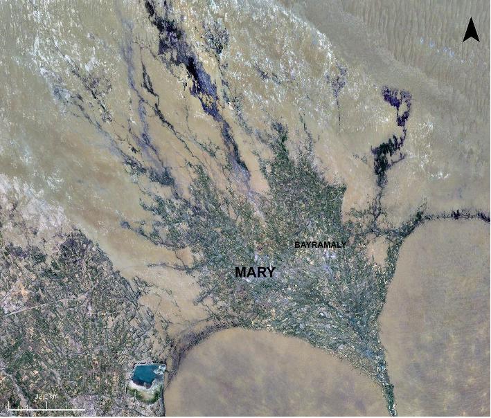 Study Area: The Murghab Delta
Remote Sensing
Satellite imagery is integral to the project. Via a combination of multispectral imagery (e.g. ASTER, LANDSAT), high resolution satellite imagery (Quickbird), ultra-high resolution UAV-based imagery (see digital elevation model below) and radar imagery, information about regional as well as local watercourses, dunes, takyrs and other features can shed light on the geomorphological trajectories over the last several millennia.
The project also examines applications of multi-temporal remote sensing data, including thermal infrared data, acquired over successive months or years to track spectral changes in the landscape over time. Thermal IR data has been shown to respond to changes in water content and soil moisture, and because it directly reflects familiar processes (i.e. heating and cooling), it can be relatively straightforward to interpret. Temperature data is an ideal way of identifying modern-day watercourses as well as recent abandoned canals and channels. Extant water tends to exhibit the coolest temperatures, while older, unused canals that may still retain moisture are slightly warmer. The warmest land surfaces tend to be active dune surfaces, whose temperatures can vary dramatically during the course of a day and can be up to 15 or 20 degrees C warmer than the air temperature.
Thermal imagery can be further exploited through time-series datasets-successively acquired images of the same area. This multi-temporal approach provides another analytical dimension by analyzing changes over a period of time.
In the Murghab, time-series thermal imagery has helped to identify likely relict watercourses, particularly in conjunction with other imagery. Because palaeochannels may be expected to be slightly depressed features and retain more moisture, the thermal variance is lower than surrounding dunes or unvegetated clay surfaces.
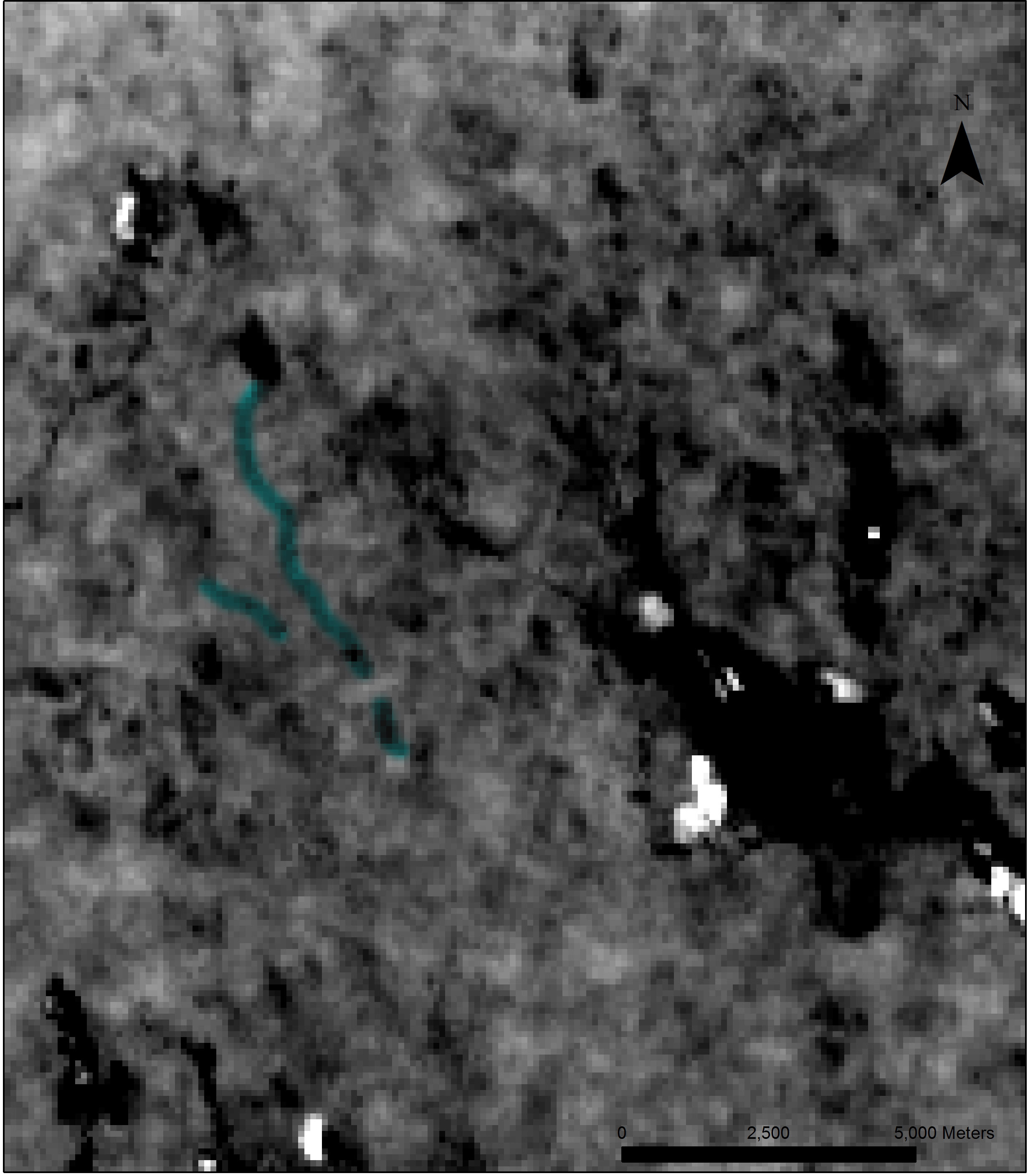
The above image was generated by taking the variance in land surface temperature (LST) over a period of 5 months from June through October.
Geoarchaeology
While remote sensing can provide valuable information about land cover and hydrology-and even some information about palaeohydrology, subsurface investigation is needed to fully trace diachronic changes in land-use and the environment. Geoarchaeology, by analyzing traces of various elements in sediments, organic materials, and changes in mineralogy.
Analyses included Optically Stimulated Luminescence dating, which can date quartz-rich alluvial and aeolian sediments. Obtaining a fine chronology of the encroachment of desert sands into the alluvial plain can be important to understand adaptation and resilience strategies in marginal regions.
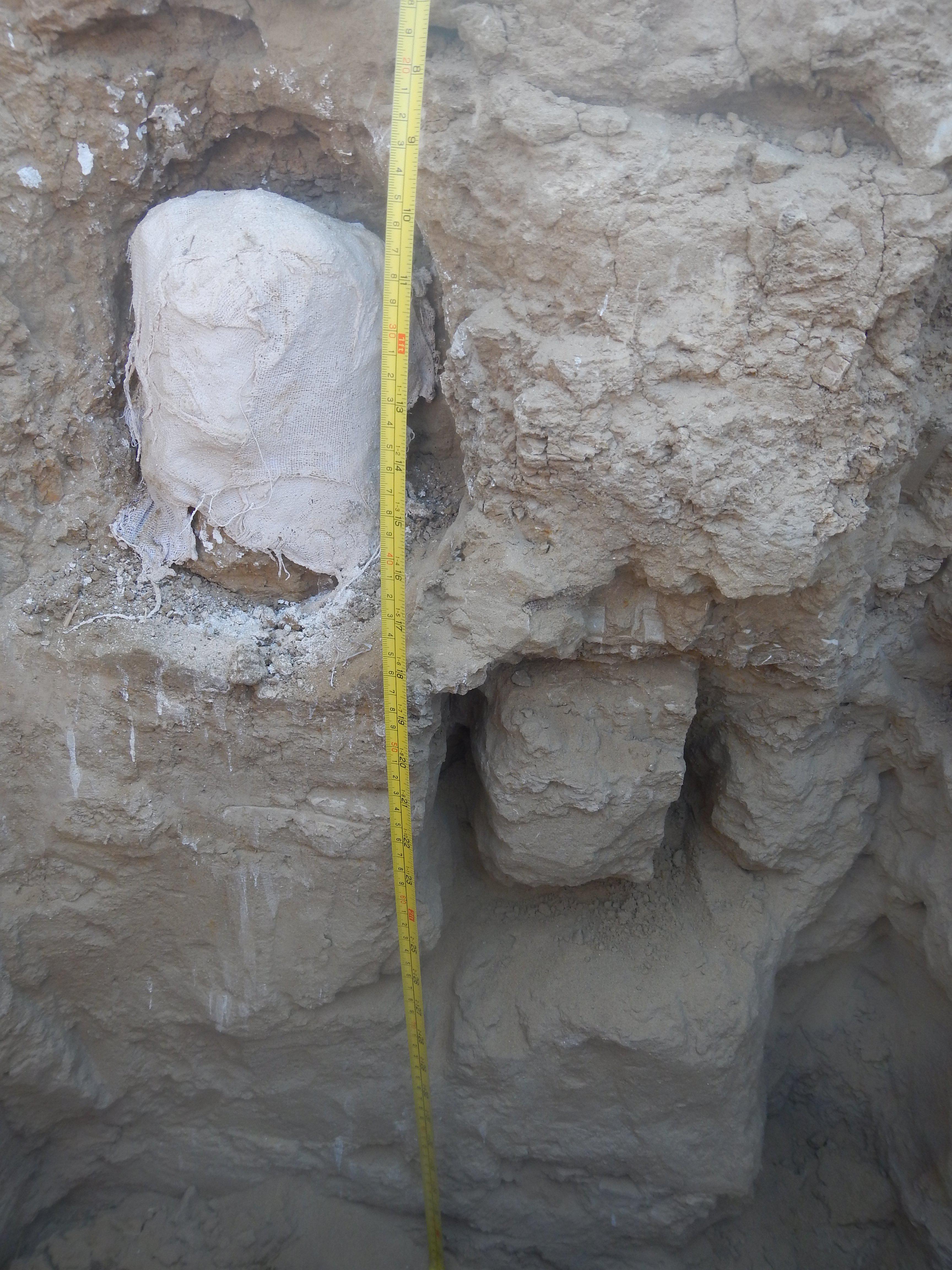
Micromorphology block. Because the sediments are extremely friable, gypsum was used for the extraction.
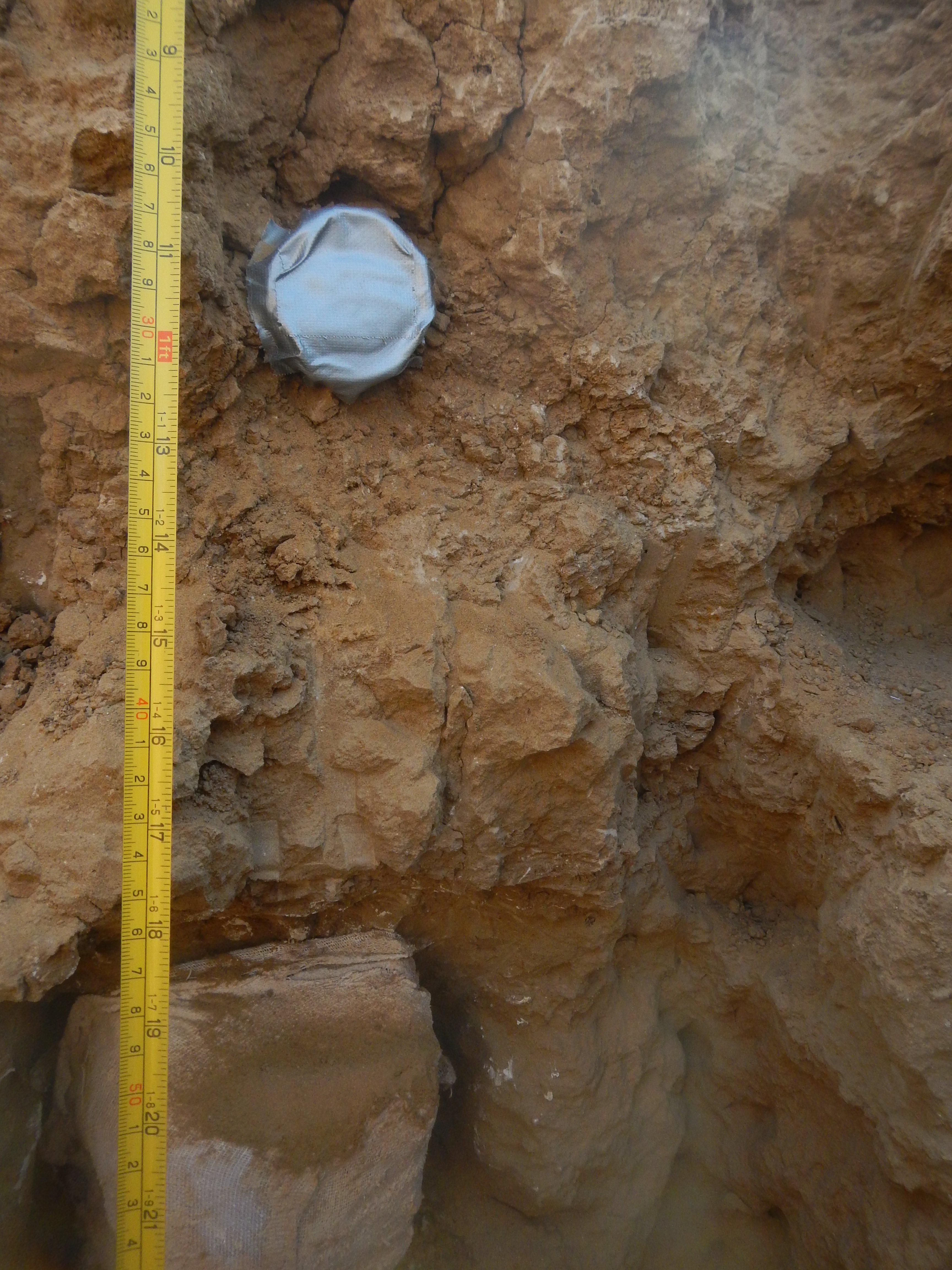
OSL dating. Tubes were inserted and extracted under a black photo-cloth to prevent exposure to light.
Other analyses include Loss on Ignition to test for organic content in the sediments, magnetic susceptibility and XRF analysis to identify trace elements.
Team
Marco Madella Universitat Pompeu Fabra
Andrea Balbo, IMF-CSIC
Published work
Perspectives on an Alluvial Margin: Settlement Patterns in the Northern Murghab Delta, Turkmenistan (forthcoming), IRAN.
Presentations
At the Edge of the Black Sands: Rethinking Convention in the Bronze Age 'Oases' of Central Asia
European Archaeological Association
September 10-14, 2014
![]() Marie Curie Actions Intra European Fellowship programme.
Marie Curie Actions Intra European Fellowship programme.
Ancient Merv Project, University College London.
National Council for Eurasian and East-European Studies
German Space Agency (DLR)
NASA