
UPF uses digital humanities to help preserve archaeological heritage in southern Asia
UPF uses digital humanities to help preserve archaeological heritage in southern Asia
Marco Madella, ICREA research professor at the Department of Humanities, is the principal investigator at UPF of the project, coordinated by the University of Cambridge with the participation of the Catalan Institute of Classical Archaeology. “Mapping Archaeological Heritage in South Asia” (MAHSA), funded by the Arcadia Fund, aims to support the body of professional archaeologists and the management of the heritage of Pakistan and India to identify and protect the historic and prehistoric heritage of the area through sustainable approaches.
, is an example of the type of archaeological sites that can be monitored remotely for assessing their preservation using the MAHSA Project methodology.")
Pompeu Fabra University, through the Department of Humanities, has taken a step forward in its growth in the field of digital humanities, as it is one of the partners of the project “Mapping Archaeological Heritage in South Asia” (MAHSA), along with the Catalan Institute of Classical Archaeology (ICAC), coordinated by the University of Cambridge (UK).
Marco Madella: ”This project is a wonderful opportunity to develop new tools for the remote sensing and protection of world heritage when most needed due to increased pressure in relation to the expansion of intensive human activities”.
The MAHSA project aims to advance in the knowledge of the archaeology of southern Asia and help the body of professional archaeologists and the management of the region’s heritage to develop more sustainable methods. Its main goal is to protect and monitor the most vulnerable heritage at risk of destruction through a digital humanities-based approach: remote sensing, machine learning and the complete digitization of existing records with conventional archaeological surveys and research based on records are some of the methods used.
MAHSA, which is to run for three years, is coordinated by the University of Cambridge (under the leadership of Cameron A. Petrie, a professor at the UC’s Department of Archaeology), along with two key partners: Pompeu Fabra University and the Catalan Institute of Classical Archaeology (ICAC). Its principal investigators are, respectively, Marco Madella, ICREA research professor of the Department of Humanities and coordinator of the Culture and Socio-Ecological Dynamics (CaSEs) research group at UPF, and Hèctor A. Orengo, Ramón y Cajal researcher and co-director of the ICAC’s Landscape Archaeology research team (GIAP).
An example of the application of digital humanities to urgent social needs
“This project is a wonderful opportunity to develop new tools for the remote sensing and protection of world heritage when most needed due to increased pressure in relation to the expansion of intensive human activities, like mining, industrial agriculture or urban development in many parts of our planet”, Marco Madella assures.
According to the ICREA-UPF research professor, this project is an excellent example of how methodologies based on digital humanities can be applied to specific and urgent social needs: “Our work, conducted in southern Asia, will create the first, most comprehensive catalogue of the heritage of this key region, which witnessed the development of the first urban civilization of the Old World (the Indus civilization) and the Mughal (or Timurid) Empire, one of the first states in Asia.
Marco Madella explains what the University will focus on: “The work by the UPF team will focus on two areas in which we have extensive experience and we have done field work over the past 20 years: the state of Gujarat, in India, and Sindh and Balochistan provinces, in Pakistan. I hope to collaborate over the next three years with numerous international colleagues and institutions coordinated by Dr. Petrie of the University of Cambridge”.
The cultural heritage in southern Asia, gravely threatened
Archaeological sites and monuments worldwide are increasingly threatened by human activities (e.g., expansion of urban areas and industrialized agriculture) and the impact of climate change.
This is particularly acute in southern Asia for several reasons: the local heritage agencies often have few resources; databases of existing archaeological sites and monuments are often either not digitized or not available; many of these sites are not yet documented and there are large areas that archaeologically speaking are still difficult to study because of their political instability.
In addition to the intensity of the natural and human threats, these factors combine to make the implementation of management planning, impact assessments and mitigation measures and monitoring particularly difficult in the long term.
Collaboration with local bodies to create a geospatial database
One of the key aspects of MAHSA is knowledge transfer and the training of the region’s heritage professionals and working with local agencies and specialists to develop a collaborative, sustainable, open access relational geospatial database that serves as the main mapping resource and repository for the protection and investigation of local heritage.
The data collected and analysed will be used to develop specific recommendations for each country for future research priorities, as well as management and mitigation strategies
The University of Cambridge, UPF and the ICAC will collaborate with local stakeholders in Pakistan and India to document endangered archaeology and cultural heritage in the Indus river basin and surrounding areas: they will work with colleagues from these two Asian countries to collect and systematize existing published and unpublished data (grey literature) on the archaeological and cultural heritage.
The data collected and analysed will be used to develop specific recommendations for each country for future research priorities, as well as management and mitigation strategies coordinated among national, regional and international heritage management agencies.
MAHSA is funded with 1.8 million pounds (about 2 million euros) by the Arcadia Fund, a charity that supports the task of preserving and protecting cultural heritage and ecosystems at risk, with the aim of defending the complexity of human culture and the natural world.
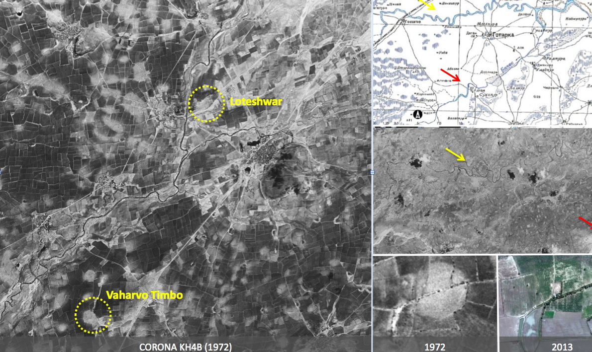
Use cases of mapping, satellite images and original photographs to identify and monitor the preservation of archaeological sites in Gujarat (India). The images show two archaeological sites: one is Loteshwar (a settlement of hunter-gatherers and agro-pastoralists dating back more than 7,000 years) and the other, Vaharvo Timbo (of hunter-gatherers of 5,000 years ago).
Both sites were identified by applying artificial intelligence to satellite images, and their “preservation history” can be assessed using CORONA (old) and Google Earth (more recent) images. The sites are clearly identifiable, but a change can be detected in the levels of conservation of Loteshwar between 1972 and 2013 (bottom-right of the picture). Evidence of heritage is also noted in the old maps of the Soviet Union of the 1950s (top-right of the illustration).